
Please can I stay just a little while longer on the Mohave?
- Pyra

- Apr 21, 2023
- 4 min read

I'm not ready to go back to the cold yet. I'd already put away my winter sweaters and brought the spring stuff to the front of my closet. However, on the first night of this trip, I was forced to dig out my favorite flannel shirt and a sweater. I wasn't about to put them away. Utah temperatures still indicated chilly nights.
After a quiet second night, I woke on the north end of Lake Mead as the predawn light filled the bedroom window. An orange-gold line pulsed at the horizon. The other camper had been right about the nights near Overton not being too cold. It was actually quite pleasant with the window open.
And the quiet. So much quiet.
For a moment, I thought about staying there one more night, but the refrigerator and stove needs propane. With my propane indicator way down by the E, I made tea quickly and packed the RV to roll.
On the way into town, I stopped at the Lost City Museum. The museum itself is built on the grounds of an old pit house, which is a prominent outdoor feature of the museum. The Lost City's webpage says this about the museum's purpose and origin:
The Lost City Museum, originally known as the Boulder Dam Park Museum, was built in 1935 by members of the Civilian Conservation Corps. The National Park Service created the museum to exhibit artifacts recovered from local prehistoric archaeological sites, most of which were flooded when the Colorado River was dammed to form Lake Mead.
Having arrived just before nine, the older couple running the front desk greeted me. The old man looked at me pointedly and said, "You're lucky you're here now. We were supposed to have 80 school children show up at 8:30. They're running late. You've got time to look around."

Instead of look around, I engaged them in conversation about the historical significance and the long-ago time. I wanted to understand the significance of this place. They discussed the idea that this was an ancient Puebloan site.
"We don't say 'Anasazi' around here. It's a derogatory term," a heavy set man on a walker suddenly piped up from the corner as he stood to his feet and moved toward where I stood at the counter.
I wanted to get back to what the man had said before. "But...what is this about Pueblo? Here?" My mind made a mental map from southwest Coloradoto the south. The Utes were in southwestern Colorado, which is now Navajo land. The Pueblo people are south of there, all throughout New Mexico. Going west from the 4-corners area, the Freemonts and the Pre-Fremonts were in mid-Utah. The Moqui (or Muckwich, according to recent scholarship) were in south-central Utah. And then there's those who lived along the Colorado River. "Aren't these the grounds of those along the Colorado River?" I asked, fishing for a name.
"Yeah," the first old guy piped up. "These were the Pueblo people."
I thought to what I'd seen in Chaco Canyon and at Chimney Rock and at other places. The circular shape and the kiva top opening aqui certainly did seem to indicate a Puebloan influence.
The movie confirmed all this as it spoke to the similarity in pottery and building design. In addition, the movie spoke to the drought in the last half of the 1200s as being the reason why the people migrated away from the area.

The school children arrived while I looked around. I left soon after. For more info on the Lost City Museum, see this site: Historic Lost City Museum Located in Moapa Valley (travelnevada.com).
Next, I rode into Overton and searched for propane. I didn't see any place that seemed to sell propane there or along the highway through the Moapa Valley, so I rode on up to Mesquite and found it at the 76 gas station. I got back on the road.
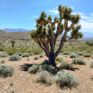
With chilly evening temperatures in Utah, I decided to camp for the weekend somewhere south of St. George. That left me with two options between Mesquite: Black Rock Road or that other place I've been wanting to camp at, the place with all the Joshua Trees.
Joshua Trees make me happy, so the choice was an easy one.
From Littlefield, I took the back way up to St. George, around the gorge. That would take me to the place I wanted to camp. With long empty distances, the land stretched out before me as the ribbon of highway came to a point way up ahead near the base of a mountain.
The engine already strained against the incline when I saw the pull off. It turns out this place is called Joshua Tree National Natural Landmark and is a habitat for the desert tortoise. (This is a great video to watch about the desert tortoise and the region.)
With this being a big-sky, dark-sky area, I'm going to try to stay here until my MRI appointment on Monday in Cedar City. I need this time to contemplate mortality and grade papers. Stay tuned for more updates soon!


Comments