
Chasing the Moqui Trail
- Pyra

- Jun 23, 2022
- 13 min read
Updated: Feb 25, 2023

With a few days off work and high gas prices staring me in the wallet, I realized I'd have to stay close. What to do in or around Escalante? People plan their vacations months or a year in advance to come here. I know because I take the reservations at the hotel and give people the brochures to all the wonderful sites: Calf Creek Falls, the Petrified Forest, and the Escalante River Trail.
I've done none of those things since arriving here over a year ago. That's not to say I haven't done some popular hikes. I've done the Peek-a-Boo and Spooky trail twice and visited the Willis Slot Canyon three times. I've been down the Hole-in-the-Rock Road...all the way to the end...and saw Lake Powell through the hole in the rock.
Also found on the Hole-in-the-Rock Road are the popular tourist sites: Zebra Slot Canyon and the Devil's Garden. I've been to both those. Along that same bumpy, dirt road, I've hiked around the historic Dance Hall Rock where the Mormon pioneers established a base camp on their San Juan mission. You can read about this exciting pioneering experience here and here.
I wanted to see something different, but with tourist season still in full swing, I didn't want to go where everyone else was going. When I got off work on Saturday night, I had to make a decision.
So, for starters, I decided to face the music...literally. I walked over to the 4th West Pub to see who was playing open mic night. I was tired and didn't really want to go, but the town just had a music extravaganza roll through with the Highway 12 Music Festival. I wanted to go and see who was playing.
When I arrived Sky, Ben, and Will were playing a hopping tune beneath the warm bare bulb lights strung across the room. After their set, one of them suggested I go get my ukulele. "I'm tired," I admitted. "I just got off work at nine." They nodded their heads in sympathy, and I left shortly after.
Back at my RV, I pulled out my ukulele and started playing. After a stunning rendition of "Jolene"--stunning in my own thinking--I just wanted to keep playing, so I packed up the uke and headed back to the pub.
I felt like a rock star when I entered through the side door and set my uke down because as soon as the music stopped, Sky looked over at me with a ready to play question. I nodded.
"Let's give it up for Pyra," Sky announced. Then, while pulling the uke out of the case, he got the crowd clapping in anticipation.
Inwardly I groaned. I should have stayed in the RV. What in the heck was I doing?
When I got to the mic, I called Ben up. God bless that man! He's quite a player and was so accommodating to come up and play right away. We played "Jolene," and it went over well. Then, I felt a little daring. I really wanted to do my "Havana > Folsom Prison Blues" in front of people and actually play all the way through. The song started well, but in the middle of the song I completely had an oh-fudge! moment. Thank God Ben was able to carry through on that until I found my place in the song again. After that, I called Sky back up and decided to listen for awhile before heading back to the RV.
The next morning, I hung around long enough to water the plants around the property and pack up the car for a car-camping trip. I was determined to do some nearby dirt-roads.
I'd never taken the Skutumpah further than Willis Creek, so I decided to take that road all the way. At the north-east end, Skutumpah starts near Kodachrome State Park. As I started toward the big first hill, I sang the obligatory tribute to Paul Simon as I threw the 4wd into place and braced myself for a steep sandy climb. At one point, I had to roll the Xterra backwards--along the side of the cliff!--to get more power to attack the sand on the upward climb.
After that initial climb, the drive was pretty easy going, bumpy in places but otherwise good. The roadway passed over Bull Valley Gorge, and I stopped to take a quick peek and to look for the vehicle sandwiched between the canyon walls.

After spotting the truck from atop the bridge, I thought momentarily about heading down into the canyon, but I remembered reading some warnings about this hike and opted against it until I did more research. Am I glad I didn't go! When I got back from my little journey, I learned that there is some quicksand in this gorge.
Skutumpah ends at Johnson Canyon Road, a paved road through some pretty country. That road landed me on 89, so I took 89 west toward Kanab. From there it was on toward St. George. I had some returns to make at the Autozone, Kohls, and Walmart.
St. George was so hot. So hot. At almost seven o'clock in the evening, the temperature on the signs from Hurricane to St. George read 106 and 104 degrees. Since I had Buena with me, I left the car running with the air conditioner on at the Autozone while I ran inside to return some hoses. By the time I got to Kohl's the temperature had dropped to 98 degrees. I parked in a shady spot, left the windows down, and ran inside to make my return. I was back out in mere moments.
I tried camping at Black Rock Road and was amazed to find the usual collection of RVs, trailers, and camper vans missing. Beneath the almost full moon, the creosote bushes swayed the steady heat-gusts of wind, while the desert floor seemed to glow in the moonlight.
Later, I learned why no one was camping there: the heat. I tried sleeping, but at midnight, the temperature had only dropped minimally to 89-degrees. Recognizing I had a long, sleepless night ahead of me, I made a quick decision, pulled on my shorts, and jumped into the driver's seat.
I pulled onto I-15 and headed north. The drive to Cedar City takes about an hour, but it also rises in elevation. And, if Cedar is too hot, I could always camp in the mountains to the east, just above the city. As I drove, I weighed my camping options while listening to Stacy on the Right on the Patriot Channel. I could camp in the Walmart lot, but...eh. Lights, traffic, and the usual 4 a.m. wake-up from the lot-sweeping machine didn't seem appealing. Instead, I'd head up the canyon and into the mountains.
I found a great little camping spot overlooking Cedar City. The temp there was 76 at 1:30 in the morning, but the steady wind was much stronger, making it feel colder. I had to put on my winter leggings and wrap myself in my sleeping bag to stay warm. With the steadily swaying Xterra acting like a cradle, I fell asleep.

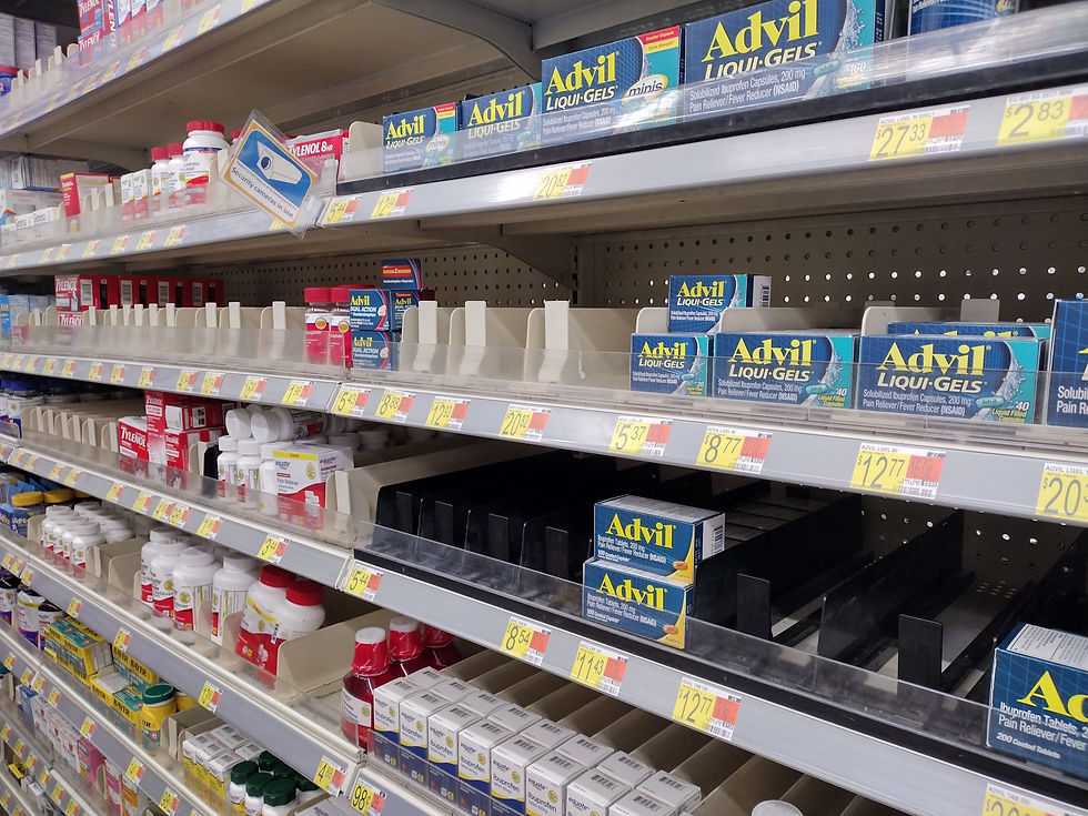
Monday morning was cool up on the mountain, but I knew it would be much warmer down in the valley, particularly as the day progressed. My plan was to get down into the city, get what I needed from the markets and get out. To that end, I made a hurried run to Walmart, Walgreen's, and Smith's grocery. I was particularly surprised by the missing products on shelves. For almost a year I've been tracking the gallon-sized jugs of Nice! water at Walgreen's. For almost a year I haven't been able to buy that particular brand. I don't know why. All I know is that those jugs of water have the best handle and thick plastic, so they are perfect for using as refill gallon jugs. Beyond that, other products were also missing from shelves. Perhaps there really is something to be said about this supply-chain problem. Perhaps it is time to be less dependent upon markets and more self sufficient.
By noon, I was back on the road to Escalante. With meat and produce in the cooler, I wanted to put the hurry in my pace and get it into the fridge as quickly as possible. I threw a couple of blankets over the cooler to help keep the cold in and the heat out, and got back to Escalante 3 hours later. (It would have been sooner except for road work on Highway 14.)
Upon arriving in Escalante, I moved quickly to unload the perishables into the fridge and freezer. With the motel office closed for the mid-day siesta, I soon found myself roped back into working when a couple of potential guests showed up and inquired about a room. I gave them information and checked them into a room. Soon after that some other guests showed up, and I checked them into their room. After that, I quickly left the front of the hotel and headed back to my RV to unload the rest of my shopping expedition.
Up to this point off, my days off have been about getting stuff done. It was time for some fun. Around four o'clock, I left Escalante and headed south down Smokey Mountain Road to continue my adventure. Before getting too far, I remembered to call and text a few people to let them know where I was going and when I planned to arrive at the other end in Big Water. Then, I put down my phone and went off grid.
The road is all dirt, sand, and rock. In places, particularly in the Alvey Wash, the deep sand requires a little bit of a running start. I gunned the engine through those sandy patches, most of which are within the road's first five miles. At the hotel, I often get asked whether or not two-wheel drive vehicles can make it to the Moqui ruins. I always say it depends on two things:
1) The driver's skill
2) The vehicle's clearance
Mostly, it's all about number one. I've taken a Chevy Cavalier, a Hyundai Santa Fe, and a Toyota Corolla places where I probably shouldn't have, but sometimes the road calls, and you must go. It's all about knowing your machine, its abilities, and your own abilities. Not that I'm anyone to talk. At this point, I still don't understand what 4-low is all about on the 4wd gear shifter.
There are some twists and rocks that have to be gently climbed, but these first thirty miles to the Moqui ruins aren't bad. The fun part is everything south--between the ruins and Big Water. That's the part that kind of scared me because of how remote and rough those roads can be.
Arriving at the Left Hand Collet junction well before sun set, I decided to try looking for the easy-to-find ruin. "It was right there," said a guest who had arrived with a group of off-road cyclists. "We stopped there and had lunch beneath the trees." I had high hopes of finding it before sun set and then finding a spot to set up camp.
A little way down the road I came upon a monolithic rock that looked moqui-like with eroded cave-like pockets. If I was an ancient Moqui, I'd build here. It looked promising with large shade trees growing throughout the large boulder field. I let Buena out of the Xterra, and we started walking around. Buena leaped ahead of me, sniffing and inspecting for lizards and chipmunks. Climbing around the huge rock, I imagined myself as an ancient, using this area as a base for foraging, hunting, cooking, and tanning hides.
Water, however, seemed absent. My elder friend, Harriet, once told me that this land was very different, even 1000 years ago. We had been climbing around on a sandstone outcropping at the time. She said that I have to remember that we are now in a drought. Water was more prevalent back then. I tried to remember that as I walked around, looking for evidence of the ruins...but finding none.
Somewhat disappointed--but still determined--I called Buena back into the Xterra and started up the rocky road. I'd still have sunlight for another two hours, so I looked for the road to the arched Moqui house. All the while, I hoped I'd find the easy-to find ruin--right off the road. We had a picnic there. If I could find that one before nightfall and find the road to the arched ruin, I'd be in good place for some morning hiking before the day heated up tomorrow.
I found the road to the arched house and traveled down it for a mile or so to see if there were any easy access points to the arched Moqui house. After getting on some side road that I thought would be a short cut (but wasn't on the hand-draw map), I decided to call it a night and turned back toward the more-familiar dirt road. After a little bit of scouting, I found a camping spot on a road I'm calling Dirt Road Pass because it is unnamed, and it runs parallel to Left Hand Collet, bypassing much of the rocky nastiness.
It turns out that I had a pretty clear cell signal from that spot, despite being about 35ish miles from Escalante to the north and 45ish miles to Big Water to the south. With nothing for miles and miles to the east or west, I wondered where the cell signal was coming from. I did see an "administrative road" sign, so maybe the feds have some cell equipment on this Bureau of Land Management-controlled area. I didn't question it too much. Instead, I plugged in the GPS coordinates for the two-story Moqui house and texted a friend for the coordinates to the arched house. The two-story shouldn't be too difficult to find, but the coordinates showed the arched Moqui would require some backcountry hiking. Despite carrying a pistol, I really didn't want to face any wild cats or rattle snakes in such a remote area by myself.

With a full moon rising in the east, I draped a sundress across the Xterra's back windows to block the light and went to sleep.
Just before sunrise, I let Buena out of the car, got dressed, and packed up my sleeping bag. At the corner of Dirt Pass Road and Croton (the side road off Left Hand Collet), I built two stone cairns, one on either side of the road. If I had time, I wanted to come back this way and see if the satellite maps were correct in showing me that the dirt pass would dump me back out at the Smokey Mountain Junction.
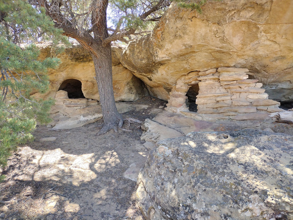
It didn't take long to find the dirt road that lead to the two-story Moqui house. I knew that the "house" would be on the side of the cliff below the ledge. "It's not too hard to get to," an old timer visiting the hotel once told me. I walked along the ridge and peered over the edge to the cliff's side, hoping it would soon come into view. After going past where I thought it should be, I turned around....and there it was!


I climbed down an explored. While these are called houses, many researchers believe they were actually used to hold grain. Upon close inspection, I also arrived at that conclusion. The space seemed awfully small for a house. In addition, the two door-shaped stones were sitting outside the "house" as if someone moved them aside from the outside. If the "house" was for human living, then those doors should be on the inside.
There was another place along the edge where it looked like the builders abandoned their work. Nothing seemed to indicate that the incomplete wall had ever been finished.
There were some other interesting slickrock outcroppings along the cliff's edge that I wanted to look at, so after satisfying my curiosity about the two-story Moqui house, I drove down another side road to look at rocks.
I got out and started to look around when the hair on the back of my neck rose up. Two different Colorado mountain men told me a few years ago: When you feel the hair on the back of your neck stand up, you're probably being tracked by a bear or a mountain lion. Trust your instincts. I called Buena, who--surprisingly!--listened to me right away, and hopped back in the Xterra. I didn't really need to look at those rocks anyway.
Back at Dirt Road Pass, I turned left and took it until it ended. I set up a large cairn at that end of the road and down the hill, which lead to the junction. As I approached the junction, I saw a Moqui house beneath some trees. "What the...?" I asked Buena. She perked up her ears and made a motion as if to hop outside. "Yes, we're getting out," I told her.
Walking around this Moqui house, I realized it was the same one I was looking for when I got out last night! If I'd gone all the way around the sandstone, I would have found it!
From there, I decided to go all the way down Smokey Mountain to Big Water. On one loose, rocky climb, the Xterra stalled out. It rolled backwards a bit as I started the engine, but I gave it some gas and made the climb. I remembered Stan told me that 4-low would keep the engine in low speed and that it would keep going and not stall out. When I got to the top of the climb, I tried out 4-low and found the engine will keep the vehicle moving forward. This will be very handy for rocky climbing conditions where I don't want the engine to stall. Yay! And I got to use it on the next rocky incline! Double yay!
The Kelly Grade is perhaps the "scariest" part of Smokey Mountain Road, particularly if you are traveling southbound. That's because the roadway is only one lane, and if you are going down, that means you are on the outside should a passing situation occur. Apparently, back in the day people said there was no way up this mountain from Big Water, but Don Kelly had a vision for completing the road and took some equipment up and made it a reality.

Once I made it to Big Water, it was only a short drive into Page. I wanted a locking gas cap from Autozone and some Taco Bell. It had been quite a long time since having Taco Bell, but it seemed like the thing to do since we have no fast food in Escalante.
After that, I headed west on 89, thinking to go through Kanab on my way back to Escalante, but I made a last-minute decision to take the only other major dirt road in the area and headed north on Cottonwood when I saw the sign pointing to the northbound dirt road. (After contacting people to let them know where I was and when I expected to have cell service, of course!)

Cottonwood Road surprised me. The electric lines running the entire length of the canyon did not detract (too much) from the magnificent rock formations. And, yes, Grosvenor Arch is truly amazing to behold. I started up the Cottonwood Road around 4ish and was out on the other end by 7:30ish.
Thinking my short adventure was over and turning my thoughts toward work, I headed east on 12. Just past the top of a section called "The Blues," a mountain lion darted across the highway. Instinctively, I reached for my camera but then pulled back my hand thinking "it's already disappeared into the weeds." However, I should have grabbed it because that huge cat turned around and ran right back across the road. Such a large magnificent creature! It was about four times the size of Buena!
Within 20 minutes I was back at the RV.
Thanks for reading my adventure! (Also....please pardon any grammatical errors or typos. This blog post has taken me about 5 days to put together. I'm trying to stay on top of inflation, so between working at the hotel, landscaping, and grading papers, I don't have much writing time these days!)


That was quite an adventure! Thanks for sharing. Great pictures. ❤️